When you click on links to various merchants on this site and make a purchase, this can result in this site earning a commission. Affiliate programs and affiliations include, but are not limited to, the eBay Partner Network.
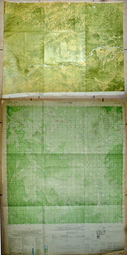
Vietnam War - US Military Map - Captured, reused by Viet Cong - Double SidedViet Cong, Invasion of Cambodia - 19782 x Map -
HIghway 9 - DMZ - Cam Lo - 1969San Tre - Cambodia - People's Army of Vietnam - 1978
Reuse of U.S. Military Maps
The Cambodian Santré map is printed directly onto the reverse of the earlier U.S. military Highway 9 / Cam Lo map.
After 1975 Vietnam inherited large quantities of former U.S. and South Vietnamese military maps, stores, equipment and printing material. Vietnam was also entering a period of severe shortages of paper, raw materials, fuel and imported supplies.
Military maps required large sheets of good quality paper. Older American maps provided an immediate supply of usable stock and were retained rather than discarded. The unused reverse could be overprinted with new Vietnamese military mapping.
This practice is known on other surviving Vietnamese maps, including Cambodian sheets printed over or on the reverse of earlier U.S. military maps.
By 1978 the People's Army of Vietnam was again preparing for major combat operations, this time against the Khmer Rouge in Cambodia. Mapping was required quickly and in quantity. Reusing existing American map stock reduced paper requirements and avoided wasting material already held in military stores.
The result with this piece is unusual in that both sides represent separate periods of the Indochina wars: the U.S. Highway 9 / DMZ battlefield of the Vietnam War on one side and a Vietnamese Army map produced for the Cambodian theatre in 1978 on the other.
A rare and unique piece, one only available.
1969 - CAM LO - DMZ - ROUTE 9 - QUANG TRI - VIETNAM WAR MAP
Original 1969 U.S. Army Corps of Engineers 1:25,000 military topographic map covering Cam Lo and the surrounding area of Quang Tri Province, South Vietnam.
Cam Lo was approximately 15 kilometres west of Dong Ha, immediately south of the DMZ and positioned directly on Route 9, the major military road running west through Camp Carroll, The Rockpile and Ca Lu to Khe Sanh and the Laos border.
Locations / Features Shown
- Cam Lo
- Cam Lo Airfield
- Route 9
- Cam Lo River
- Southern Boundary - Demilitarized Zone
- Cam Lo District
- Gio Linh District
- Huong Hoa District
- Khe Tri
- Khe Duyen
- Khe Gio
- Khe Khi
- Nui Ba Tum (Hill - 254 Metres)
- Nui Kiem (Hill - 250 Metres)
- Nui Ho Khe (Hill)
- Nui Da Bac (Hill)
- Nui Tot Mon (Hill)
- Deo Tan Lam (Mountain Pass)
- Song Trinh Hinh (River)
- Song Ngan (River)
Numerous smaller villages, hamlets, streams, roads, tracks, bridges and elevations are also shown.
Cam Lo - Leatherneck Square - DMZ
Cam Lo formed the south-western point of Leatherneck Square, the US Marine defensive area extending through Dong Ha, Gio Linh and Con Thien immediately below the DMZ.
This northern Quang Tri sector was one of the principal battle areas of the Vietnam War. US Marines, ARVN and North Vietnamese forces fought continually for control of the roads, hills, river crossings and approaches leading south from the DMZ.
Cam Lo was also part of the defensive system associated with the McNamara Line, established across northern Quang Tri to detect and disrupt North Vietnamese infiltration through and around the DMZ.
Route 9 - Khe Sanh
Route 9 was the main east-west military supply route from Dong Ha and Cam Lo to the western bases and Khe Sanh.
North Vietnamese forces repeatedly attacked, mined and ambushed the route.
On 24 January 1968 elements of the NVA 320th Division ambushed a Marine Rough Rider convoy between Dong Ha and Camp Carroll. Further fighting followed as Marine units moved to reopen the road and clear NVA positions overlooking the route.
During the Battle of Khe Sanh, the 320th Division operated against Route 9 between Ca Lu and Khe Sanh in an attempt to isolate the Marine Combat Base.
In April 1968 the 1st Cavalry Division, US Marines and ARVN forces launched Operation Pegasus. Airmobile forces advanced west along the Route 9 corridor, reopening the road and breaking the siege of Khe Sanh.
Cam Lo - NVA 320th Division
Cam Lo remained directly involved in the fighting following Khe Sanh.
In August 1968 the NVA 320th Division again crossed the DMZ and moved into positions around Cam Lo. The 3rd Marines deployed north of the Cam Lo River and engaged the 8th Battalion, 64th Regiment, beginning another series of actions against NVA forces operating south of the DMZ.
Operation Kentucky, conducted from November 1967 until February 1969, covered the wider DMZ battlefield around Con Thien, Gio Linh and Cam Lo and involved repeated clashes with elements of the NVA 320th and 324th Divisions.
MACV-SOG - Command and Control North
Cam Lo and Route 9 were within the northern operational area controlled by MACV-SOG Command and Control North.
CCN was headquartered at Da Nang and conducted classified Special Forces operations throughout northern South Vietnam, the DMZ, Laos and North Vietnam.
Khe Sanh and the Route 9 corridor were important to these operations. MACV-SOG Recon Teams operating from the northern bases conducted cross-border reconnaissance, intelligence collection, sabotage, trail surveillance and target identification against the North Vietnamese supply network in Laos.
These small teams generally combined US Special Forces personnel with Nung, Montagnard and other indigenous troops and operated far beyond conventional US positions.
Cam Lo Airfield
Cam Lo Airfield is shown beside the town, Route 9 and the Cam Lo River.
Cam Lo therefore combined road, air and river communications immediately behind the DMZ battlefield and on the principal route west towards Khe Sanh.
The map covers a major Vietnam War operational area associated with Leatherneck Square, the DMZ, Route 9, Khe Sanh, Operation Kentucky, Operation Pegasus, the NVA 320th Division and MACV-SOG Special Operations.
San Tre - Anti Khmer Rouge - Cambodia War - 3rd Indochina War 1978
1978 - SANTRE - PURSAT - CAMBODIA - VIETNAM PEOPLE'S ARMY - KHMER ROUGE WAR MAP
Original Vietnam People's Army 1:50,000 military topographic map covering Santré and the surrounding area of Pursat Province, Cambodia.
Sheet 5733 II - Series L7016.
The original mapping was prepared by the U.S. Army Map Service Far East in 1964, using Cambodian and French Indochina geographical information. This example was reprinted by the Map Department, General Staff, People's Army of Vietnam in October 1978.
The map was printed two months before the Vietnamese Army launched its full-scale invasion of Democratic Kampuchea on 25 December 1978.
Locations / Features Shown
- Santré
- Stung Santre (River / Stream)
- Phnum Peam Trabek (Mountain - 768 Metres)
- Phnum Damrei Slab (Mountain - 429 Metres)
- Phnum Kantout (Mountain - 345 Metres)
- Phnum Kde (Mountain)
- Phnum Roleap Samrai (Mountain)
- Phnum Banteay (Hill / Mountain)
- Phnum Veal Tranh Ampil (Hill / Mountain)
- Vatt Chambak Meas (Temple)
- Ph Dong Pol
- Ph Reang Khvay
Numerous smaller villages, jungle tracks, streams, river crossings and mountain positions are shown throughout the sheet.
Santré - Pursat - Cardamom Mountains
Santré lies in Pursat Province on the approaches to the Cardamom Mountains.
The map shows the transition from the more open plains and river valleys of Pursat into heavily broken mountain terrain, dense forest, narrow tracks and numerous streams.
This terrain became central to the war after the Vietnamese invasion. Khmer Rouge forces driven from the major towns withdrew into the western and south-western mountains, where the Cardamom range provided concealment, difficult access and routes towards the Thai border.
Santré and the Stung Santre valley sat on the approaches between the Pursat lowlands and this mountain area.
Vietnam - Khmer Rouge War
Relations between Vietnam and Democratic Kampuchea had deteriorated into open warfare by 1977.
Khmer Rouge forces repeatedly crossed the Vietnamese border, attacking military positions and civilian settlements. Vietnam responded with increasingly large cross-border operations during 1977 and 1978.
By late 1978 the conflict had developed into full-scale war.
On 25 December 1978 the Vietnamese Army crossed into Cambodia in force. Phnom Penh fell on 7 January 1979 and Vietnamese formations continued west through Kampong Chhnang, Pursat and Battambang while other forces advanced towards the Cambodian-Thai border.
Pursat - Khmer Rouge Retreat
Pursat became part of the principal western retreat from Phnom Penh.
Pol Pot and other senior Khmer Rouge leaders withdrew from Phnom Penh towards Pursat before continuing west towards Battambang and the Thai frontier.
Vietnamese forces followed the retreat along the western axis while Khmer Rouge units abandoned the major towns and regrouped in the surrounding jungle and mountain areas.
Within weeks Khmer Rouge forces were again attacking Vietnamese positions around Kampong Chhnang, Pursat and Battambang.
The fighting then changed from conventional invasion to a prolonged guerrilla war.
Cardamom Mountains - Khmer Rouge Operations
The Cardamom Mountains became one of the principal Khmer Rouge military refuge areas.
Units established camps, supply routes and operating areas throughout the mountains and continued attacks against Vietnamese and People's Republic of Kampuchea forces.
The difficult mountain and jungle terrain shown across this map was well suited to guerrilla operations. Roads were limited, movement depended heavily on tracks and river valleys and many of the mountain positions dominated the surrounding approaches.
Vietnamese forces conducted repeated operations into these areas during the years following the 1978 invasion as Khmer Rouge units continued to operate from western Cambodia.
Why the Vietnamese Army Had This Map
By 1978 the former North Vietnamese Army and Viet Cong forces had been incorporated into the unified People's Army of Vietnam.
The Vietnamese General Staff reprinted existing U.S. Army mapping of Cambodia for military use. The October 1978 printing date places this map directly within the period of Vietnamese preparations for operations against Democratic Kampuchea.
Santré is well inside Cambodia, west of the Vietnamese border. The sheet covers terrain on the western operational axis towards Pursat and the Cardamom Mountains.
Mountain heights, streams, river crossings, villages, tracks, forest cover and routes through the mountains were all essential information for Vietnamese units moving into an area where Khmer Rouge forces were withdrawing from the conventional battlefield and establishing guerrilla bases.
The October 1978 Vietnamese military printing date, Pursat location and Cardamom Mountain approaches place this map directly within the opening period of the Vietnamese-Khmer Rouge War and the subsequent Vietnamese campaign against Khmer Rouge forces in western Cambodia.
Vietnam War - Cambodia War - 3rd Indochina War - Double sided MAP
- Measures - 29 x 22.5 inches ( 74 x 59 cms )