

|
Site Categories |
|
Featured Items |

Poodle, Spaghetti Trim, Ucagco


|
Vintage 1926 Washington State National Forests Road Map US Forest Service... For Sale

When you click on links to various merchants on this site and make a purchase, this can result in this site earning a commission. Affiliate programs and affiliations include, but are not limited to, the eBay Partner Network.

Vintage 1926 Washington State National Forests Road Map US Forest Service...:
$72.99
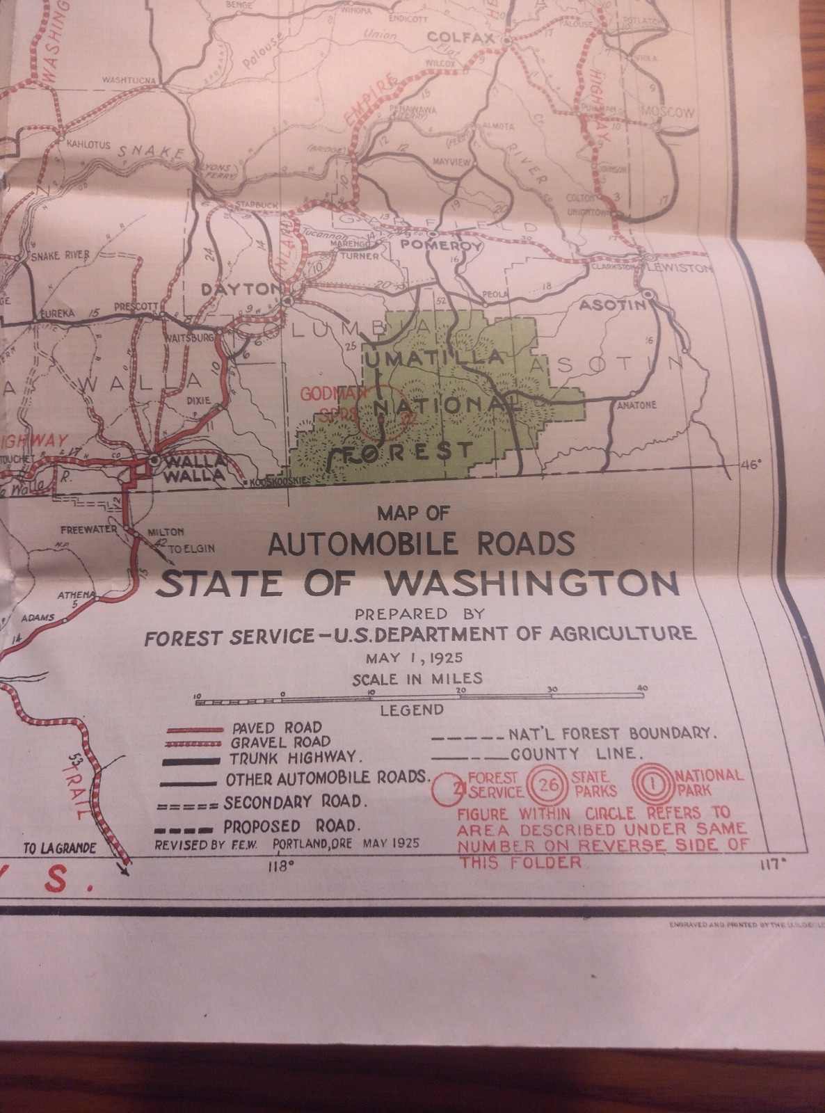
Vintage 1926 \"Road and Information Map for the National Forests of Washington\" Published by the United States Department of Agriculture (USDA) Forest Service Up for sale is a rare, authentic piece of Pacific Northwest automotive and conservation history. This original 1926 folding informational brochure opens up into a large, detailed \"Map of Automobile Roads, State of Washington\" (compiled/revised in May 1925 by the Forest Service office in Portland, Oregon). This is a fantastic, highly cross-collectible item perfect for historians, map enthusiasts, forestry collectors, or early automotive buffs. Key Features & Historical Highlights: - Iconic Snoqualmie Pass Cover Photo: The front cover features a beautiful historic photograph captioned: \"Guye Peak, from Sunset Highway at Snoqualmie Pass, Snoqualmie National Forest.\" It depicts a fantastic early vintage touring car with travelers on the historic dirt highway.
- Pre-Smokey Bear Era Conservation Slogan: Features a prominent vintage red shield stamp on the interior map reading \"Prevent Forest Fires — It Pays.\" This early public service campaign predates the 1944 creation of Smokey Bear.
- Pre-National Park Geography: Shows the Olympic Peninsula labeled as the \"Olympic Nat\'l Monument\" centered around Mt. Olympus—a full decade before it was officially designated a National Park in 1938.
- Historic Transportation Networks: Details early 1920s travel corridors, showcasing paved vs. gravel roads, historic ferry crossings (connecting Victoria BC, Port Townsend, and San Juan Islands), and early infrastructure around Mt. St. Helens, Hood Canal, and the Umatilla National Forest.
- Complete Document: Includes both the highly visual photographic front/back covers and the massive inner fold-out map intact.
Condition Report: This map is in Good/Very Good Vintage Condition considering its 100-year age and intended use as an active travel guide. - The paper shows original folding creases from publication.
- There is expected light edge wear, minor fraying along some folds, and typical small separations at a few cross-fold corners.
- The graphics, text, and printing remain clear, legible, and vibrant. No major stains, heavy foxing, or severe damage.
- Please review all high-resolution photos carefully to evaluate the exact condition for yourself.
|
|
Related Items:
Vintage 1926 Postcard Germany Comic Woman Falls With Fold Out City Views $3.00

Vintage 1926 Holland America Line Playing Cards Deck Slide Case Fortuna Dutch $145.00
Vintage 1926 Shamokin Pennsylvania Fire Association Pinback Pin $76.00
|
|
|
Shopping Cart  |

|
Recently Viewed |
|
Latest Items |
|
Facebook |
Secure Websites

|
