When you click on links to various merchants on this site and make a purchase, this can result in this site earning a commission. Affiliate programs and affiliations include, but are not limited to, the eBay Partner Network.
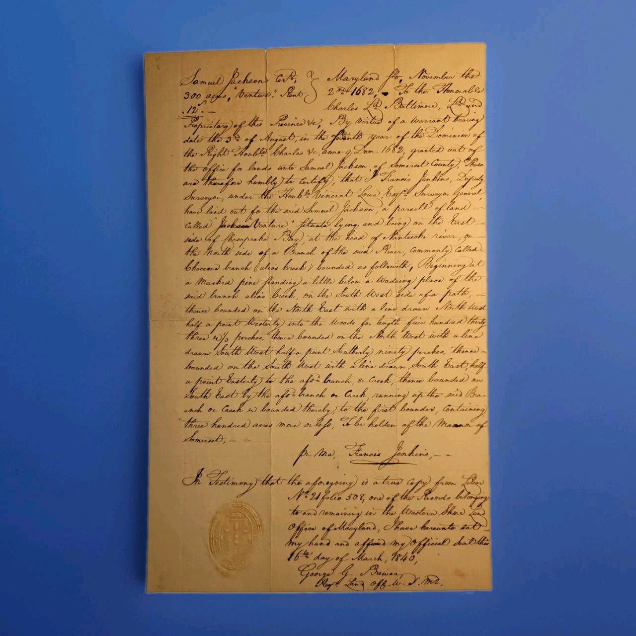
Offered here is an exceptional three-document Maryland land-record archive concerning the colonial tract known as “Venture” or “Jackson’s Venture,” a 300-acre property originally surveyed for early Somerset County settler Samuel Jackson on November 2, 1682.
The surviving documents were assembled or certified in the 19th century through the Maryland Land Office, and together preserve and investigate the history of a land claim originating during the proprietary government of Charles Calvert, 3rd Lord Baltimore.
The principal document is an official March 16, 1840 certified transcript of the original 1682 certificate of survey, copied from Liber No. 21, Folio 508 of the Maryland land records. It is signed by George G. Brewer, Register of the Land Office for the Western Shore of Maryland, and bears the office's original embossed seal.
Also included is Brewer's separate March 16, 1840 handwritten research memorandum, explaining his search of the colonial records for the tracts called “Venture” and “Plymouth.” Brewer states that he located the survey certificate for Venture but apparently found no recorded patent for it. He therefore supplied a sealed copy of the certificate and discusses his efforts to determine whether this was the same “Venture” referenced in the Plymouth patent. He further notes that the rent rolls record the surveys but disclose no transfers before the American Revolution.
A third related manuscript records the survey description and bearings associated with the tract.
Together, the three documents form a fascinating example of 19th-century title research into a 17th-century Maryland landholding.
The 1682 “Venture” Survey
The certificate records a tract of approximately 300 acres surveyed for:
Samuel Jackson of Somerset County, Maryland
The land was called:
“Venture”
and was situated:
on the east side of Chesapeake Bay, at the head of the Nanticoke River, on the north side of a branch commonly called Cheecocone / Cheecon's Branch, alias Creek.
The survey begins at a marked pine near a wading place and proceeds by compass bearings through the woods before returning along the branch or creek to the place of beginning.
The tract was to be held of the:
Manor of Somerset
The survey was made pursuant to a warrant dated August 3, 1682, during the proprietary rule of Charles Calvert, Lord Baltimore.
The original survey was executed by:
Francis Jenkins, Deputy Surveyor
under:
Vincent Lowe, Surveyor General of Maryland.
The Maryland State Archives confirms that Lowe served as Surveyor General from 1679–1683 and again from 1685–1692, placing him in office at precisely the time this tract was surveyed.
Samuel Jackson — Early Somerset County Planter
Samuel Jackson was an early English colonial settler and planter in the lower Eastern Shore region of Maryland.
Historical documentation indicates that Jackson came to Somerset County from Virginia by the 1660s. Maryland historical-property research identifies him as a planter who was already acquiring land along the Nanticoke River watershed well before the Venture survey. In 1668, land called “Long Hill” was surveyed for Jackson in the Wetipquin/Nanticoke area.
One surviving local history further identifies Jackson's first recorded Maryland land acquisition as a tract on Wetipquin Creek off the Nanticoke River, demonstrating that his association with this exact part of Maryland predates Venture by roughly fourteen years.
By 1682, Jackson therefore appears not as a transient claimant but as an established Somerset County landholder participating in the rapid English settlement of Maryland's Eastern Shore.
Later Somerset County records also identify a Samuel Jackson as a vestryman of Stepney Parish in 1697, although this listing should be treated as supporting evidence rather than absolute proof that every Samuel Jackson reference concerns precisely the same individual.
The present documents are particularly important because they preserve the official survey of one of Jackson's early landholdings and later evidence of an effort to reconstruct its chain of title.
Francis Jenkins — Deputy Surveyor, Sheriff, Judge & Maryland Legislator
Francis Jenkins (ca. 1650–1710) was one of the more important public figures in late-17th-century Somerset County.
At the time Venture was surveyed, Jenkins served as Deputy Surveyor, operating under Surveyor General Vincent Lowe.
His public career extended far beyond surveying. Contemporary Maryland records document Jenkins as a county justice and, beginning in 1683, Sheriff of Somerset County, a position he held during much of the 1680s.
He subsequently became involved at the provincial level in Maryland politics and government. Jenkins participated in Maryland's legislative and judicial life during a turbulent period that included the Protestant Revolution of 1689, which displaced the Calvert proprietary government.
His surviving survey work is historically valuable because surveyors such as Jenkins physically translated proprietary warrants into actual boundaries on the landscape. They identified marked trees, streams, bearings and distances that became the legal geography of colonial Maryland.
The signature or name of Francis Jenkins appearing on the 1840 certified transcript is a copied rendering from the original 1682 record, not an original Jenkins autograph.
Vincent Lowe — Surveyor General of Maryland & Brother-in-Law of Lord Baltimore
Vincent Lowe (d. 1692) was one of the most politically connected officials in proprietary Maryland.
Born in England, Lowe immigrated to Maryland around 1670 and became a planter, attorney and government official. He served as Sheriff of Talbot County, sat in Maryland's Upper House, and was appointed Surveyor General of Maryland, holding that office from 1679–1683 and 1685–1692.
Lowe's political importance was enhanced by an extraordinary family connection: his sister Jane Lowe Sewall married Charles Calvert, 3rd Lord Baltimore, making Vincent Lowe the proprietor's brother-in-law. A Maryland Historical Magazine account specifically identifies Lowe as Lord Baltimore's brother-in-law, a member of the Provincial Council and Surveyor General.
His position therefore placed him at the center of Maryland's proprietary land system.
As Surveyor General, Lowe supervised the provincial surveying apparatus under which Francis Jenkins laid out Samuel Jackson's Venture tract.
At his death in 1692, Lowe was an extremely substantial Maryland landowner; the Maryland State Archives records more than 13,000 acres associated with his estate.
Charles Calvert, 3rd Lord Baltimore — Proprietor of Maryland
The warrant underlying this survey was issued under the authority of Charles Calvert, 3rd Baron Baltimore (1637–1714/15).
Charles Calvert was the son of Cecil Calvert, 2nd Lord Baltimore, and inherited the proprietorship of Maryland after his father's death.
Unlike the earlier proprietors, Charles spent considerable time personally governing Maryland. He came to the colony in 1661 and served as its principal proprietary governor before succeeding as Lord Baltimore. The Maryland State Archives describes him as the first proprietor of Maryland actually to reside in the colony.
His administration was defined by the Calvert family's effort to govern Maryland as a proprietary colony while maintaining religious and political control amid growing Protestant opposition.
The family was Roman Catholic, an increasingly consequential fact in the late 17th century. In 1689, Protestant Associators overthrew the proprietary government. Calvert ultimately lost direct political control of Maryland, although the family's proprietary claims survived and were later restored to his descendants.
The Venture survey therefore dates from the final decade of the original Calvert proprietary administration before the political upheaval of 1689.
George G. Brewer — Register of the Maryland Land Office
The most important 19th-century figure in the archive is George G. Brewer.
Brewer served as Register of the Maryland Land Office from 1827 until 1851, a tenure of approximately twenty-four years. The Maryland State Archives specifically credits Brewer with arranging and recording important bodies of surviving colonial land-office material during his tenure.
A later official history of Maryland's land administration likewise lists:
G. G. Brewer — Register for the Western Shore
and notes that in 1841 the Eastern Shore Land Office was transferred to the Western Shore office.
Brewer's role makes these documents much more than ordinary private copies.
On March 16, 1840, he personally certified the Venture transcript:
“a true copy from Liber No. 21 folio 508”
from records remaining in the Western Shore Land Office of Maryland.
He signed the document in his official capacity and affixed the embossed Land Office seal.
The accompanying manuscript memorandum is particularly interesting because Brewer describes his own archival investigation. He found a copy of the patent for “Plymouth,” but for Venture he located only the certificate of survey rather than a patent. He therefore issued the sealed certified certificate.
Brewer further compared the records with information supplied by a Mr. Hooper, investigated the Maryland Rent Rolls and noted that he could find no transfers of the relevant tracts before the Revolution.
Brewer remained involved in Maryland public administration beyond the Land Office and is documented in the 1840s as Chief Clerk of the Maryland House of Delegates.
Thus, both his signature and the Land Office seal on the certified document are original to 1840.
“Mr. Hooper”
Brewer's accompanying letter refers to a “Mr. Hooper,” whose own letter apparently stated that the tract in question had been taken up by Samuel Jackson in 1682.
At present, this individual cannot be identified with sufficient certainty to attach a responsible biography.
The important point is that Hooper appears to have been directly involved in the title investigation that prompted Brewer's archival research. His information caused Brewer to compare the tract mentioned in the Plymouth patent with the only Jackson tract he could find from approximately 1682.
Rather than speculate about which member of the numerous Maryland Hooper families he was, the listing preserves him simply as Mr. Hooper, a correspondent or researcher associated with the 1840 title inquiry.
Historical Importance
This archive documents two different periods of Maryland history simultaneously.
The underlying record belongs to the world of proprietary Maryland in 1682:
Charles Calvert, Lord Baltimore, controlled the colony.
Vincent Lowe served as Surveyor General.
Francis Jenkins acted as Deputy Surveyor in Somerset County.
Samuel Jackson was acquiring land along the Nanticoke River.
Property boundaries were established by marked trees, creeks, compass bearings and measured distances.
Land was held under proprietary institutions such as the Manor of Somerset.
The physical certified documents belong to 1840 Maryland, when George G. Brewer and the state Land Office were preserving, copying and interpreting those colonial records.
Brewer's accompanying letter demonstrates that these papers were apparently produced as part of an actual chain-of-title or ownership investigation, not simply as antiquarian souvenirs.
His inability to locate a recorded patent for Venture is especially interesting. The Land Office had the original survey certificate on record, but Brewer could apparently locate no corresponding patent. He consequently supplied the certified survey itself and examined rent rolls for evidence of ownership transfers before the Revolution.
Documents Included
1. Official certified copy of the 1682 “Venture” certificate of survey
Dated March 16, 1840.
Certified by George G. Brewer, Register of the Western Shore Land Office.
Copied from Liber No. 21, Folio 508.
Includes the original embossed Western Shore Land Office Jackson
Venture / Jackson's Venture
300 acres
Somerset County
Nanticoke River
Cheecocone / Cheecon's Branch
Manor of Somerset
Francis Jenkins
Vincent Lowe
Charles Lord Baltimore
August 3, 1682 warrant
November 2, 1682 survey
2. George G. Brewer handwritten Land Office memorandum
Dated March 16, Jackson
Mr. Hooper
the absence of a recorded patent for Venture
Maryland Rent Rolls
absence of located transfers prior to the Revolution
Brewer's decision to issue a sealed certified copy of the survey certificate
Signed by George G. Brewer in his official capacity.
3. Related manuscript survey / certificate document
Contains the metes-and-bounds description of Venture, including compass bearings and distances, and references the same historical land-office record.
The three papers have remained together as a related archival grouping and are being offered together, not separated.
Condition
Original antique documents showing expected age-related wear, toning, folds, minor staining and handling.
There are areas of separation and loss along old folds on portions of the manuscript material, as visible in the photographs.
The principal 1840 certified copy remains highly presentable, with strong manuscript writing and a clearly visible embossed official seal.
Please examine all photographs carefully, as they form an important part of the condition description.
Collector Interest
An outstanding archive for collectors or researchers of:
Colonial Maryland • Somerset County • Nanticoke River • Eastern Shore Maryland • Lord Baltimore • Calvert Family • Colonial Land Patents • Early American Surveying • Maryland Land Office • Francis Jenkins • Vincent Lowe • Samuel Jackson • Genealogy • Property History • 17th-Century American History
The group provides a compelling paper trail connecting a 1682 Lord Baltimore-era Maryland land survey with an official state investigation of that same property 158 years later in 1840.