When you click on links to various merchants on this site and make a purchase, this can result in this site earning a commission. Affiliate programs and affiliations include, but are not limited to, the eBay Partner Network.
1880 U.S. Army Signal Service Weather Map Archive
War Department Weather Map — Fourth Quarter, October–December 1880
Imperial Folio | Approx. 270+ Daily Weather Maps | Birth of U.S. Forecasting
A monumental U.S. Army Signal Service weather map archive: a complete imperial folio volume preserving the official daily American weather maps for the fourth quarter of 1880.
Produced by the War Department’s Signal Service, this volume contains the tri-daily meteorological maps for October 1 through December 31, 1880, recording national weather observations at 7:35 A.M., 4:35 P.M., and 11:00 P.M. Washington time.
This is not a single map or a small group of loose sheets. It is a complete bound governmental archive: approximately 270+ full-page weather maps, issued during the formative decade of modern American weather forecasting.
Historical importance
The U.S. Army Signal Service was central to the creation of nationwide weather observation and forecasting in the United States.
In 1870, after destructive storms in the Great Lakes region, Congress directed military posts throughout the country to communicate weather observations for the benefit of commerce and agriculture. The Army Signal Corps was then tasked with building an effective national weather service under Chief Signal Officer Albert J. Myer. The National Museum of the United States Army notes that the Signal Corps issued daily weather summaries and predictions and telegraphed reports to and from agricultural centers across the country; by the 1880s, the Corps was heavily occupied by weather duties. In 1890, this work was transferred to the Department of Agriculture and became the United States Weather Bureau, predecessor of the National Weather Service.
This volume belongs directly to that formative period.
The weather maps
Each day is represented by three full-page maps:
- 7:35 A.M.
- 4:35 P.M.
- 11:00 P.M.
The maps display coordinated weather observations across the United States, including:
- Temperature readings
- Barometric pressure
- Wind direction
- Storm systems
- Isobars and isotherms
- Station data
- Continental weather patterns
Old World sales notes that War Department weather maps began publication by the Signal Service in January 1871, made possible by the telegraph network, and were intended for practical use by merchants and farmers. Their description of an 1873 example notes observations from more than 50 locations, including temperature, barometric pressure, wind speed, precipitation forecasts, and an accompanying weather summary.
A real-time record of late 1880
This volume covers October through December 1880, the opening months of the severe winter of 1880–81.
The archive captures atmospheric conditions as they unfolded day by day and hour by hour across the United States. For historians of weather, climate, agriculture, transportation, the northern plains, frontier life, and the early national forecasting system, this is an unusually rich primary source.
The period is also culturally resonant because the winter of 1880–81 later became associated with frontier accounts of extreme winter conditions, including those connected with Laura Ingalls Wilder’s The Long Winter.
Binding
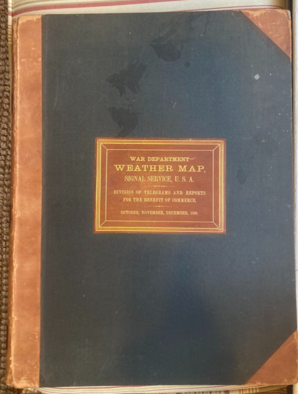
Original War Department institutional binding.
The volume is bound in half leather over heavy boards, with a central gilt-stamped label:
WAR DEPARTMENT WEATHER MAP
SIGNAL SERVICE U.S.A.
The binding is large, heavy, and utilitarian, designed to preserve a substantial governmental record rather than to serve as a decorative commercial book.
Physical details
Title: War Department Weather Map, Signal Service U.S.A.
Institution: U.S. Army Signal Service / War Department
Date range: October 1 – December 31, 1880
Format: Imperial folio
Approx. dimensions: 24 x 18 inches
Weight: approx. 29 lbs before packing
Contents: Tri-daily U.S. weather maps for the quarter
Estimated map count: approx. 270+ maps
Binding: Original War Department half-leather binding over heavy boards
Condition
Very good overall for a large, heavily constructed governmental folio of this age.
The maps are exceptionally well preserved, with clean, supple paper, strong color, and excellent legibility. The printed weather data, isobars, isotherms, station information, and map details remain clear and highly displayable.
The binding shows expected wear from size and use, including rubbing to corners, edges, and leather surfaces. Inner hinges have been sympathetically reinforced to support the structure, which is typical and appropriate for a folio of this scale and weight. Boards remain secure and the volume is usable with care.
Please review all photos carefully. This is a very large and heavy item, approximately 29 lbs before packing. Shipping will require careful packing and may be expensive.
Collector appeal
A remarkable survival for collectors and institutions interested in:
- Early U.S. weather forecasting
- U.S. Army Signal Service history
- War Department publications
- American meteorology
- 19th-century scientific mapping
- Daily weather maps
- Climate and environmental history
- Great Plains / frontier history
- Large-format government archives
- Chromolithographed scientific graphics
Individual War Department weather maps are sometimes encountered separately, but complete bound quarterly archives of this size and scope are rarely seen on the market.
A foundational American scientific archive documenting the early national weather system in real time.