When you click on links to various merchants on this site and make a purchase, this can result in this site earning a commission. Affiliate programs and affiliations include, but are not limited to, the eBay Partner Network.
【 Item Description 】
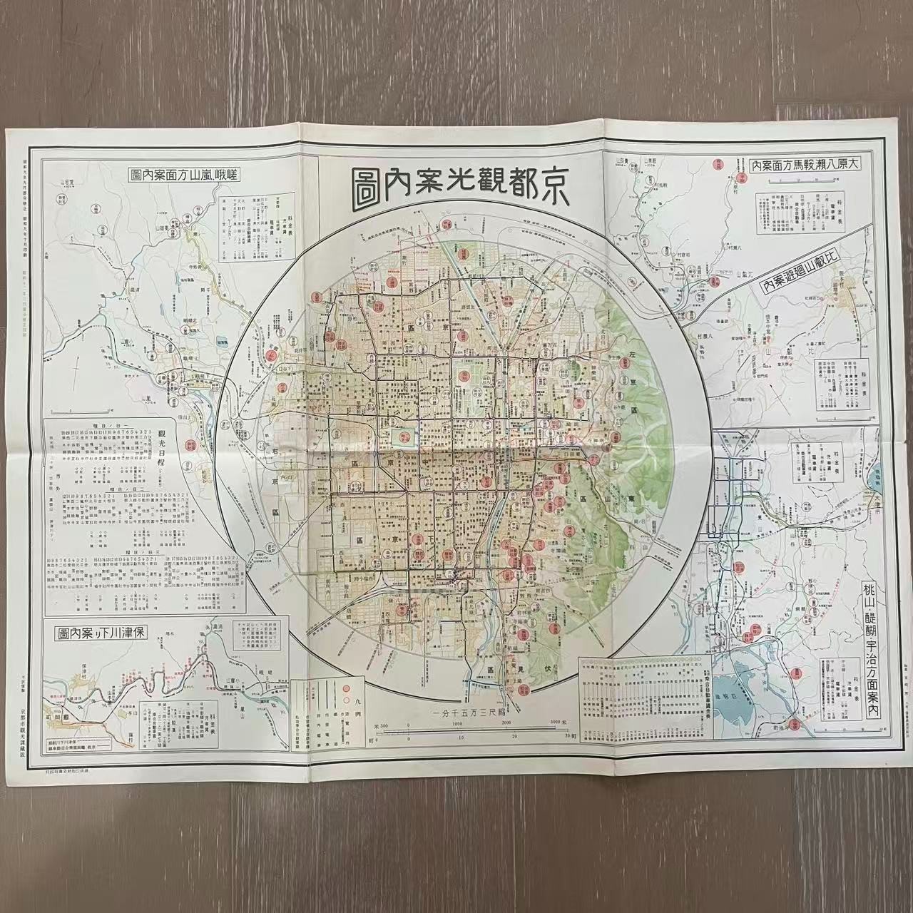
Offered here is an original vintage Japanese folding tourist map titled “京都観光案内図” (Kyoto Tourist Guide Map), produced during the prewar Showa era.
The printed margin states:
Partial revision: September 1934
Printed: October 1934
A later green Showa 11 (1936) marking is also visible along the margin, suggesting a subsequent update or issue marking.
The map presents a highly detailed view of central Kyoto with streets, transportation routes, temples, shrines, parks, government buildings, and major sightseeing destinations. Numerous important landmarks are highlighted in colored circles throughout the city.
Additional inset maps include tourist areas and excursion routes such as:
- Arashiyama / Sagano area
- Ohara / Yase / Kurama area
- Momoyama / Daigo / Uji area
- Hozugawa River sightseeing / boat route
The lower margin identifies 京都市観光課蔵版, indicating publication/issue by the Kyoto City Tourism Section.
A fascinating piece of Japanese travel history showing Kyoto shortly before World War II, ideal for collectors of antique maps, Japanese ephemera, Kyoto history, transportation history, or prewar tourism memorabilia.
Approximate unfolded size: about 24\" x 16\".
Please refer to the ruler photos for additional size reference.
【 Condition Report 】
Good vintage condition for its age.
Original fold lines are present from storage and use, along with light age-related toning, minor wrinkles, and small signs of edge/corner wear. The printed colors and fine map details remain very attractive and clearly visible.
The reverse side is largely blank.
No major missing sections or severe damage are visible in the photos. Please carefully review all photographs for the exact condition, folds, edges, and surface details.
【 A Personal Note from the Seller 】
This is an especially interesting piece for collectors of early Japanese tourism material. The combination of the large central Kyoto city map, colorful temple and shrine markings, transportation routes, and multiple surrounding sightseeing maps makes it much more visually engaging than a simple street map.
Its clearly printed Showa 9 / 1934 date also places it firmly within Japan’s prewar period, giving it strong historical and decorative appeal.
【 Shipping & Handling 】
Your item will be carefully packed to protect the original folds, edges, and printed surface during shipment.
We take special care when shipping vintage paper items and collectible ephemera. Tracking will be provided whenever available.
Thank you for visiting adVintage Picks!